Longsleddale, Westmorland
The Valley of Longsleddale
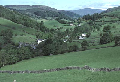
Looking northwest from the southern end of the valley of Longsleddale. Photo taken from a field above the junction where the valley road leaves the A6, near Watchgate, about 7 km from Kendal. The buildings in the left foreground are at Garnett Bridge on the River Sprint. High fells of the valley sides and mountainous terrain beyond Sadgill form the skyline. St Mary's church is about half way up the valley and Tillshole farm lies close to the northern end of the valley, on the west bank of the River Sprint.
(Photograph Hud-lon-001, Russell Hudson, July 1986)
General Descriptions of the Valley of Longsleddale
The valley of Longsleddale occurs to the north of of Kendal in the eastern Cumbrian Lake District, previously the County of Westmorland. Many authors have described the valley in glowing terms - extracts from a few of those descriptions are reproduced below:
A. Wainwright, a respected Lake District artist and writer, in his book "Three Westmorland Rivers" (Publisher: Westmorland Gazette, Kendal, 1979) has a drawing of the scene depicted in the photograph above. Wainwright describes his drawing ("The Valley of Longsleddale") as follows: "Throughout the whole length of the A6, from London to Carlisle, no fairer scene is presented to travellers on this highway than that briefly glimpsed from the road near Watchgate when journeying north. Down on the left and extending far into the hills beyond a middle distance of scattered farmsteads and woodlands is a perfect picture of quiet rural charm - the valley of Longsleddale, a green strath inured amongst shaggy fells. This is a view of classic beauty and is always so no matter how often one sees it."
Parson and White's District of Cumberland and Westmorland (Kendal Directory, 1829) describes it in glowing terms: "Long-Sleddale township and chapelry is a mountainous and picturesque district, 6 miles in length and 3 in breadth, extending southward from the lofty Harter Fell to Potter Fell, within 5 miles north of Kendal, and intersected by the Sprint rivulet, which runs through the deep vale, parallel with the road by which tourists from Kendal approach the sublime mountain scenery round Haweswater. Verdant green fields rise from each side of the rivulet in irregular swells, till the rocky declivities of the mountains preclude all cultivation, except brushwood and coppices, which climb up the steep banks, and in some places find support even in the craggy precipices, which here present their lofty and rugged fronts with much grandeur, having, in many places, beautiful cascades spouting and tumbling from their summits, and sometimes broken by gusts of wind into clouds of spangled moisture".
Kelly's 1894 Directory of Cumberland and Westmorland gives the following description: "The scenery throughout the dale is probably unsurpassed by any in the county, and it has the great additional charm of being perfectly natural and free from the intrusion of any artificial effects. The Sprunt (sic) rivulet runs through the dale parallel with the road, and on either side the mountains rise grandly to some considerable heights, including, on the east, Cripplebarrow (1,683 feet) and Whiteside Pik (1,302 feet); and on the west, Brunt Knott (1,400 feet) and Sleddale Forest, north of which, at a height of 1.010 feet, is Skeggles Water, a small tarn: the upper portion of the dale is bleak and unproductive, but here and there green sward or thickly wooded coppices cover the mountains almost to their summits, and from among the rocks, cascades dash down and swell the river below: near the head of the dale are quarries producing a fine blue slate. The soil is light loam; subsoil, sammel. The chief crop is grass. The area is 6,735 acres; rateable value 1.944 pounds, and the population in 1891 was 135". "This dale is said to have been the original of the "Long Whindale", described in Mrs Humphrey Ward's well-known work "Robert Elsmere".
F.M. Wilson (1912) wrote an illustrated guide entitled “Longsleddale”, which contains the following descriptions: "Longsleddale is the first of the grand and romantic valleys of Westmoreland encountered on entering Lakeland via Kendal. This beautiful part of the country was seldom visited in times past, no doubt owing to the fact that no conveyance of any sort ran to such an out of the way place However, visitors from a distance seem to have found out its beauties at last, and it is thought worth while running conveyances once a week to this lovely valley, only nine miles from Kendal, which is said to be the scene of part of Mrs Humphrey Ward’s “Robert Elsmere.” In it Mrs Ward describes it as a valley through which runs a beautiful river, supplied by becks running down the hillsides, through which a narrow road buried with grasses of “May” runs in a line of white through the greenness of the pasture. This is June, the leafy month of the year, when Longsleddale looks at its best."
"As we go along, the countrysides passed through are thoroughly typical of Westmorland’s most characteristic beauties: quaint farmsteadings, half hid in their sycamore groves; hedgerows, aglow with wild flowers; lovely vistas of verdant pastures and wild moorland; with ever, beyond all, lines of mountain blue and grey, seamed with precipices and scored with gorges of a hundred streams. The wild blue hyacinths carpet the woods so that not a green blade is to be seen, and the yellow of the gorse and broom make a bright patch of colour on the landscape.
The scenery throughout the dale is probably unsurpassed by any in the country, and it has the additional charm of being perfectly natural and free from any artificial effects. The mountains rise grandly on either side of the valley, and from among the rocks, cascades dash down and swell the River Sprint below, on its way to join the Kent. The broken sides of the mountains in rainy weather (and it is often raining here) are white with streams pouring from precipice to precipice, in long lines of foam. One of the most remarkable of these cataracts is called Galeforth Spout. It falls about 100 yards in an unbroken sheet. When a wind from the valley catches the water in its fall, it forces it upward in a sort of light vapourous column, which is often mistaken for smoke.
Some of the farm houses and cottages in Longsleddale are very picturesque, and deserve the attention of artists. Between Sadgill and the Slate Quarries the rocky barriers and the huge fragments of stone which have tumbled from them furnish a grand spectacle. There is a fine walk over Nanbeil Pass into Kentmere.
Towards the head of the valley the dale grows more narrow, rocky, and abrupt, till you think you can penetrate no further. As we leave the church, it assumes a wild, lonely and most solemn aspect, dividing Longsleddale from Mardale, with the grim and ghastly “Goat Scar” on the left and the bold masses of “Tarn Craga” on the right.
The pathway up to the elevated plateau of Gatesgarth is very steep and rough, but when you reach the top, the view is indescribably grand. On the one side is the beautiful Mardale valley, and on looking back you see the range of Kentmere hills in all their beauty of form and colour; the Yorkshire hills - Ingleborough; a little further on Morecambe Bay; and nearer, the town of Kendal.
The Parish has no village of its own name, but there are two hamlets, Stockdale and Sadgill; the former containing two, and the latter three houses.
At Sadgill you will hear the mournful sound of the water as it dashes over the waterfall and amongst the rocks: it is about a mile up the glen, a little to the left of the Mardale track. There is no public house, no hostelry of any sort in the dale. The coach “puts up” at the Fishwick’s Farm. Here you will be well attended to and entertained at the same time. Mine hostess is widely and deservedly famed.
The church of St. Mary’s was erected in 1863 by Lady Howard, on the site of an earlier building. A carved oak door opening to a recess in the vestry bears the date 1662, and there is an oak chest dated 1719. The Communion Plate includes a Silver Chalice dated 1571. The chapel of Longsleddale was licenced for a place of burial by W. Dawes, Bishop of Chester, in 1712.
The names of the hills round about Longsleddale still speak of a race of animals which lived in these dales at no distant date. Goat Scar, Ravens Crag, Buckbarrow, Buck Crags and Catbarrow. It is only a few years since the last of the large vulture tribe was shot somewhere about Grey Crag.
An extensive view may be had from the top of Capel Barrow, which is not a difficult climb though it is 1683 feet above sea level.
Whiteside Pike, 130 ft., is on the east side of Longsleddale. On the west, Brunt Knott, 1400ft. and Sleddale Forest, north of which, at aheight of 1017 ft. is Skeggles Water, a small tarn near the head of the dale. In the north is Rangill Head, a mountain containing fine blue slate, which was used extensively towards the end of the eighteenth century.
The dale is said to have received its name from the family of Sleddall, which claims to be descended from Sledda, the Saxon King. In this quiet dale, there is not much to break in upon the monotony of life, and the greatest interest is taken in strangers who visit the place. The population in 1901 was 144.
There is a famous well not far from Buckbarrow, the neighbourhood of which is a happy hunting ground for botanists in search of rare plants. Sweet violets, wild geraniums, globe flowers, occasionally a butterfly orchid, royal ferns, parsley ferns, staghorn moss, all flourish here."
History of the Valley of Longsleddale
"The dale is said to have received its name from the family of Sledall, which claims to be descended from Sledda, the Saxon King" (Wilson, 1912). In medieval times the valley of Longsleddale was almost certainly part of an ancient travelling and trading route that linked a number of the early abbeys and religious centres, including Shap Abbey. Thus, Wainwright (1979) writes: "Lower Sadgill stands at the end of the old road coming over the tops from Kentmere, probably part of an ancient highway and trade route that formerly crossed south-east Lakeland using a succession of low passes over the hills"; and "Bridge End occupies an enviable position on the old road traversing the west side of the Sprint and is connected with the motor road on the east side by a footbridge on a supporting causeway of large stones. The old road, reached by vehicles via Nether House Bridge, continues in the close company of the river for three pleasant miles and rejoins the motor road near Sadgill, and there seems no doubt that it has been in use since medieval times, was favoured by packhorse trains and may have been the more important of the two routes up the valley. But it was the present road on the east side that was promoted to seniority by a surface of tarmac".
St Mary's Church, Longsleddale
St Mary's Church, Longsleddale
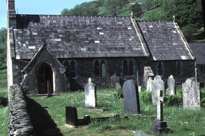
The church is on the east side of the River Sprint, and about half-way up the valley of Longsleddale. The churchyard contains a number of headstones, but brief searches by Marion Charles, myself and others did not locate any graves belonging to our Hudson forebears. A small schoolroom is located across the road from the church.
The following description, from the novel "Robert Elsmere" (see further extracts below), is thought to based on St Mary's church:
"Across the road, rose a freshly built church, also peaked and gabled, with a spire and two bells, and a painted east window, and Heaven knows what novelties besides."
(Photograph Hud-lon-031, Russell Hudson, 1986)
Financial Support is Needed for Repairs to the St Mary's Church, Longsleddale
In July 2007, the Longsleddale PCC prepared a statement and request for funding based on the urgent need for repairs to the roof and certain walls of St Mary's Church. The repairs go far beyond the scope of the routine maintenance and decoration undertaken by the Longsleddale PCC and have been estimated to have an approximate cost of ₤40,000. It is most unlikely that this daunting sum can be raised with donations from local residents combined with such external grants that are available. As a consequence, the Longsleddale PCC hopes that some additional financial support for the project may come from others with links to the valley of Longsleddale and St Mary's Church. Such donors could include those with ancestors or friends who have lived in the valley, businesses with associations with Longsleddale, and holidaymakers, fell-walkers or others who have visited Longsleddale for rest and recreation. Common goals for these donors will be the desire to assist in the preservation of the church and thereby sustain the legacy left by earlier residents of the valley, and to ensure the continuation of an important community facility for future generations.
Donations may be made by cheques payable to: "PCC of Longsleddale Parish Church" and forwarded to The Treasurer, PCC of Longsleddale Parish Church, Low Swinklebank Cottage, Longsleddale, Kendal LA8 9BD. If you would prefer to make a donation by direct transfer of funds, I suggest you contact the Treasurer at the above address to obtain details of the name and number of the Longsleddale PCC Account and their bank in Kendal.
All donations to the church restoration fund will be acknowledged and a book of names of donors will be kept in St Mary's Church. The donations, together with the name and address of donors (in block capitals), must be received by 31st January 2008 if they are to be recorded.
Some Notes on the History of St Mary's Church
A map of the county of Westmorland indicates that a chapel was established in 1670 at Longsleddale (Long Sleddale), presumably responsible to the church in Kendal. Wainwright (1979) states: "Longsleddale's parish church of St Mary is situated on a knoll above the river, midway along the valley. It was a chapel of Kendal until rebuilt in 1712, then being given parochial status. The present church is the result of further rebuilding in 1863. Some fittings have been retained from the older structures, notably a carved oak door dated 1662 and a silver chalice dated 1571".
Further details of the church's history are given by Wilson (?date): "The church of St Mary's was erected in 1863 by Lady Howard, on the site of an earlier building. A carved oak door opening to a recess in the vestry bears the date 1662, and there is an oak chest dated 1719. The Communion Plate includes a Silver Chalice dated 1571. The chapel of Longsleddale was licensed for a place of burial by W. Dawes, Bishop of Chester, in 1712".
In Parson and Whites' 1829 Kendal Directory, District of Cumberland and Westmorland, the following details are given: "The chapel stands near the centre of the dale .... It was re-built and had a burial ground consecrated in 1712. It has been several times augmented, viz. in 1713 with 80 pounds, given by the heir and four daughters of Henry Holme, and in 1746, 1773 and 1775, with three lots of 200 pounds each, from Queen Anne's bounty, and a subscription of 200 pounds, making altogether 880 pounds, laid out for the purchase of land in Long-Sleddale, Selside and Lambrigg, now let for about 50 pounds a year. The Hon. F.G. Howard, of Levens Hall, is lord of the manor, and allows the master of the Chapel School 15 pounds per annum for teaching poor children. Most of the estates are enfranchised. The principal mansion in the dale was Ubery, or Ubarrow Hall, now occupied by a farmer, and having an ancient tower with walls two yards thick. The Rev. Henry (probably Edward, see below) Greenwood is the incumbent, and the landowners are patrons of the curacy".
Note: A list of residents (patrons of the curacy) of Longsleddale is given in the above directory and comprises the Rev. Edward Greenwood, a tailor, three slate quarry proprietors, and a schoolmaster, together with 22 farmers, of which 5, including Thomas Hudson of Tillshole (listed as "Hill sole"), are Yeomen. Edward Greenwood was also listed in the parish records as "Curate" in baptisms in 1828 and "Perpetual Curate" in burials in 1832. He also officiated as "Curate" for the wedding of Thomas Hudson and Isabella Green in 1815.
Kelly's 1994 Directory of Cumberland and Westmorland provides the following addditional information. "The Church of St Mary, situated on an eminence in the dale, is a building of stone in a plain Gothic style, consisting of chancel, nave, south porch, and a western turret containing one bell: there are 120 sittings. The register of baptisms dates from 1670; marriages 1679; and burials 1712. The living is a perpetual curacy, gross yearly value 160 pounds, with 10 acres of glebe and residence, in the gift of the vicar of Kendal, and held since 1884 by the Rev. William Burrows M.A. of the University of London. National School (mixed), built in 1863, for 45 children; average attendance 26; Thomas B. Wright, master”.
Water Mills on the River Sprint
The River Sprint was used to generate power for a variety of mills during the Industrial Revolution. These are described by Wainwright (1979). "One cannot explore the course of these rivers without becoming fascinated by the remarkable number of mills on their banks that in days gone by have used their waters to drive machinery. Many of these mills in the rural areas were small, cottage-size or less, and most have disappeared leaving relics in the form of weirs, sluices and races. Only one out of almost seventy such mills still continues to this day to use a waterwheel, all other wheels falling into disuse as new means of power became available over a century ago. Also of profound interest are the prehistoric settlements, burial mounds, ancient enclosures and field systems that have survived in the valleys from early occupations". The following mills are known to have been developed along the Sprint in the valley of Longsleddale (Wainwright, 1979).
| Name of Mill | Location | Notes |
|---|---|---|
| Stockdale Fulling Mill | ?Stockdale Barn | Mentioned in 14C documents |
| Longsleddale Corn Mill | Revegill; Kilnstones | A 13C corn mill associated with Shap Abbey; noted in document dated 1263 |
| High Mill | Near Cocks Close | A 19C bobbin mill; also known as Sleddale Foot Mill and Wilson Mill |
| Garnett Bridge Saw Mill | Garnett Bridge | A 19C bobbin mill; ? on site of earlier mill |
| Garnett Bridge Corn Mill | Garnett Bridge | 18C and 19C corn mill; closed in the 1920's |
| Baxenholme Mill | Near Gurnal Bridge | 14C corn(?) mill |
| Oakbank Mill | Oak Bank | Built about 1850 as a bobbin mill |
| Sprint Mill | Near Sprint Bridge | Corn mill on the site of two fulling mills; then used as a woollen mill |
Wainwright writes: "Sprint Mill stands in idyllic surroundings on a curve of the river. Now used for other purposes, this mill was the largest on the Sprint, having in its time served as a corn mill and later as a woollen mill; earlier the site was occupied by two fulling mills. It was also the last mill in the Sprint, the confluence with the Kent being only a short mile distant, beyond Sprint Bridge"; and also "The road meets the valley floor above the gorge that gave power to ... Garnett Bridge, another hamlet that was associated with industry. For the next four miles farmsteads, mainly of seventeenth-century origin, follow each other along the valley, standing alone or clustered in hamlets."
Longsleddale - Probable Setting for the Novel “Robert Elsmere”
The following paragraphs come from an introduction, written by Rosemary Ashton, to an edition of the novel published by Oxford University Press in 1987.
"Mrs Humphry Ward’s highly successful novel “Robert Elsmere” was first published in 1888, when the author was 36. It was probably the best and certainly the most successful of her twenty-five novels, and became an immediate and enduring best seller. Within a year of publication it appears to have achieved sales of about 40,000 copies in Britain and 200,000 in America. In an introduction to the Westmorland Edition of her works (published by Smith, Elder in sixteen volumes in 1911), Mrs Ward reckoned that “not far short of a million copies of the work have been distributed in the English-speaking countries, and translations of it have appeared in most foreign languages.
Mrs Ward was born Mary Augusta Arnold in Tasmania on 11 June 1851. She was the first child of Tom Arnold and Julia Sorrell, who met and married in Hobart in 1850, and the grand-daughter of Dr Thomas Arnold of Rugby. Tom Arnold had gone first to New Zealand where he unsuccessfully farmed some land which the late Dr Arnold (he died in 1842) had acquired some years previously, before he turned to teaching, took up a post in Hobart, and eventually became inspector of schools. In 1856, her father became a Roman Catholic and the family sailed for England and then Dublin, where he taught at the new Catholic University, while the family spent five years of “straightened means and constant struggles, passed in dismal furnished houses.” In 1862, the family, now with eight children moved to Birmingham, where Mary felt the family’s circumstances would have been intolerable but for the physical and symbolic “home” to which they went for holidays, Dr Arnold’s house near Ambleside, Westmorland, presided over by his widow.
"Throughout this time of poverty and stress, Thomas Arnold’s old home, Fox How - the grey stone house and beautiful garden in the Lakes, where Arnold of Rugby had passed his holidays - was often a place of paradise to the Tasmanian children. Nor was it only the garden and the fells that made their mark. Inside the house there were the influence of a home life which had been moulded by the personality of Arnold of Rugby, by his high intelligence, his unworldliness, his religious faith."
The novel tells movingly of a young clergyman, Elsmere, whose loss of orthodox faith puts a great strain on his marriage to a staunchly evangelical wife. Mrs Ward covers the religious history of the nineteenth century, describing the Oxford of Newman and the Tractarians and showing Elsmere assailed by the arguments against orthodoxy - emanating from European biblical criticism, geological and evolutionary discoveries, and social liberalism - which faced the Victorians. Mrs Ward died on the 24 March, 1920 aged 68.
The following passages from” Robert Elsmere - Book I, Westmoreland” describe the valley of Long Whindale (which is based on the valley of Longsleddale):
Chapter I. "It was a brilliant afternoon towards the end of May. The spring had been unusually cold and late, and it was evident from the general aspect of the lonely Westmoreland valley of Long Whindale (Longsleddale) that warmth and sunshine had only just penetrated to its bare green recesses, where the few scattered trees were fast rushing into their full summer dress, while at their feet, and along the bank of the stream, the flowers of March and April still lingered, as though they found it impossible to believe that their rough brother, the east wind, had at last deserted them. The narrow road, which was the only link between the farmhouses sheltered by the crags at the head of the valley and those far-away regions of town and civilisation suggested by the smoke wreaths of Whinborough (based on Kendal) on the southern horizon, was lined with masses of the white heckberry or bird-cherry, and ran, an arrowy line of white, through the greenness of the sloping pastures. The sides of some of the little becks running down into the main river and many of the plantations round the farms were gay with the same tree, so that the farmhouses, gray-roofed and gray-walled, standing in the hollows of the fells, seemed here and there to have been robbed of all their natural austerity of aspect, and to be masquerading in a dainty garb of white and green imposed upon them by the caprice of spring.
During the greater part of its course the valley of Long Whindale is tame and featureless. The hills at the lower part are low and rounded, and the sheep and cattle pasture over slopes unbroken by either wood or rock. The fields are bare and close shaven by the flocks which feed on them; the walls run either perpendicularly in many places up the fells or horizontally along them, so that, save for the wooded course of the tumbling river and the bush-grown hedges of the road, the whole valley looks like a green map divided by regular lines of grayish-black. But as the walker penetrates farther, beyond a certain bend which the stream makes half-way from the head of the dale, the hills grow steeper, the breadth between them contracts, the enclosure lines are broken and deflected by rocks and patches of plantation, and the few farms stand more boldly and conspicuously forward, each on its spur of land, looking up to or away from the great masses of frowning crag which close in the head of the valley, and which from the moment they come into sight give it dignity and a wild beauty.
On one of these solitary house the afternoon sun, about to descend before very long behind the hills dividing Long Whindale from Shanmoor, was still lingering on this May afternoon we are describing, bringing out the whitewashed porch and the broad bands of white edging the windows into relief against the gray stone of the main fabric, the gray roof overhanging it, and the group of sycamores and Scotch firs which protected it from the cold east and north. The western light struck full on a copper beech, which made a welcome patch of warm colour in front of a long gray line of outhouses standing level with the house, and touched the heckberry blossom which marked the upward course of the little lane connecting the old farm with the road; above it rose the green fell, broken here and there by jutting crags, and below it the ground sank rapidly through a piece of young hazel plantation, at this present moment a sheet of bluebells, towards the level of the river. There was a dainty and yet sober brightness about the whole picture."
Chapter II. "The vicarage .... was a new gray stone building with wooden gables, occupying the site of what had once been the earlier vicarage house of Long Whindale, the primitive dwelling-house of an incumbent whose chapelry, after sundry augmentations, amounted to just twenty-seven pounds a year.
Across the road, in front of the Long Whindale parsonage .... rose a freshly built church, also peaked and gabled, with a spire and two bells, and a painted east window, and Heaven knows what novelties besides. The primitive whitewashed structure it replaced had lasted long, and in the course of many generations time had clothed its moss-grown walls, its slated porch, and tombstones worn with rain in a certain beauty of congruity and association, linking it with the purple distances of the fells, and the brawling river bending round the gray enclosure. But finally, after a period of quiet and gradual decay, the ruin of Long Whindale chapel had become a quick and hurrying ruin that would not be arrested. When the rotten timbers of the roof came dropping on the farmer’s heads, and the oak benches beneath offered gaps, the geography of which had to be carefully learnt by the substantial persons who sat on them, lest they should be overtaken by undignified disaster; when the rain poured in on the Communion Table and the wind raged through innumerable mortarless chinks, even the slow-moving folk of the valley came to the conclusion that “summat ‘ull hev to be deun”. And by the help of the Bishop, and Queen Anne’s Bounty, and what not, aided by just as many half-crowns as the valley found itself unable to defend against the encroachments of a new and “moiderin” parson, “summat” was done, whereof the results - namely, the new church, vicarage, and schoolhouse - were now conspicuous."
Geology of Longsleddale
Rocks from Longsleddale in the Walls and Roof of Tillshole
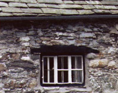
The seventeenth century farmhouse was constructed of rocks found in the the hillside scree, the glacial deposits of the valley, and mined from nearby quarries. The house walls contain rocks from the older Borrowdale Group and from younger (Silurian) limestones and shales. Slate tiles, from quarries beyond the end of the valley, form the roof of the farmhouse.
(Photograph Hud-lon-011, Lawrie Davidson, 1981)
Dr Ken McNamara studied the volcanic and sedimentary rocks which underlie the soils and moraines of the valley of Longsleddale, and are exposed in the rugged crags and fells of the valley sides. Some of the following account has been extracted from his 1979 publication:
The southern Lake District is underlain by a thick sequence of Silurian strata that unconformably overlie the Borrowdale Volcanic Group. The steeply-dipping WSW-ENE contact between these major lithologic groups is exposed within the valley of Longsleddale between Sadgill and Tillshole. Here, the Borrowdale Volcanic Group lies at the northern end of the valley, forming the rugged, mountainous region beyond Sadgill. The Coniston Limestone Group, a group of largely fossiliferous sedimentary rocks, dips to the southeast. McNamara has described the various lithological units (exposed in a section from from the head of the valley towards the southeast) as consisting of:
BORROWDALE VOLCANIC GROUP (Older rocks at the northern end of Longsleddale)
This group of rocks, older than about 400 million years, consists of rocks of volcanic origin, rocks composed of fragments of volcanic rocks, and inter-bedded sedimentary rocks. These rocks have been deformed and altered, and their resistant character has caused them to remain as much of the mountainous terrain within the Lake District.
Slate Quarries at the head of the valley of Longsleddale
Parson and White's Kendal Directory, 1829 states: "At Rangle-Gill, near the head of the dale, are extensive quarries of the finest blue slate". They list Sinkinson, Wilson and Walker as being slate quarry proprietors of Rangle-Gill.
CONISTON LIMESTONE GROUP (Younger fossiliferous Silurian rocks)
Longsleddale Formation. Alternating sequences of poorly-sorted conglomerate, containing andesite and rhyolite in a pale green, silty matrix, overlain by red shales and red and green siltstones, in turn overlain by red shales. The total thickness varies from 20 to 30m. No fossils have been obtained from the type section of the Longsleddale formation, however away from the type section the formation is variable in thickness down to 2 or 3m and comprises coarse sandstones which in some localities have yielded fossils.
Stile End Formation. This consists of a sequence, up to 28m thick, of calcareous siltstones and silty limestones with frequent solitary rugose corals and compound tabulate corals. A restricted fauna, dominantly trilobites and brachiopods, is present.
Yarlside Rhyolite. The Yarlside Rhyolite conformably overlies the Stile End Formation in the Longsleddale district, but is absent away from the valley. The rhyolite appears to have flowed into the sea and was laid on unconsolidated sediments. The upper surface shows local development of conglomerate, presumably due to marine erosion.
Applethwaite Formation. The type section is a 55m thick sequence of limestones, calcareous mudstones and shales. The formation is locally rich in fossils with a fauna comprising trilobites, brachiopods, bryozoans and gastropods.
Troutbeck Formation. At Brow Gill, Longsleddale this formation is represented by 1m of argillaceous limestone and lies unconformably on the Applethwaite Formation. The High Pike Formation, a facies variant of the Applethwaite formation, is not represented at Longsleddale, nor are the White Limestone and Torver Formations, which are developed to the west of the valley (see McNamara, Fig.7)
Ashgill Shale Formation. The Ashgill Shale can be distinguished by its lower calcareous content from underlying formations. It consists of dark blue-grey shales, rarely containing limestone nodules. In the type section the sequence is 20m thick, but at Longsleddale, 500m upstream from the junction with Stockdale Beck, only 1.3m of shale rest, apparently conformably, on the Troutbeck Formation. The formation is poorly fossiliferous.
SILURIAN SKELGILL BEDS. These overly the Ashgill Formation at Longsleddale.
Geomorphology of Longsleddale
The main geomorphological features of the valley of Longsleddale are glacial in origin, and have been modified by subsequent fluvial action by the River Sprint. Some details are provided by Millward and Robinson (?date), and are summarised in Map 8 of their description:
"The road meets the valley floor above the gorge that gave power to Garnett Bridge, and on the opposite flank, close to Nether House, there is a pasture full of uncleared boulders and bracken that preserves an image of Long Sleddale from the days before the period of slow and painful medieval colonisation. As one enters the middle part of the dale about Ubarrow Hall the course of the River Sprint has been straightened through a badly drained former lake floor. This section of the valley closes with a rock bar, plastered with moraine, that provides the site for the church..... Above the rock bar and shallow gorge the valley widens again; its gentle lower slopes are extensively covered with morainic material. The river cuts through a narrow belt of moraine above Sadgill, and in the valley floor, behind and higher than the moraine, there are traces of a little common field, once shared by the farms of the hamlet. The highest section of Long Sleddale belongs to the wilder scenery of the Borrowdale Volcanic Series. The road winds its way up the edge of a five hundred foot-high rock step to the basin of Wren Gill and its abandoned slate quarries."