Discovery of Gold at Clunes, Victoria
Topography
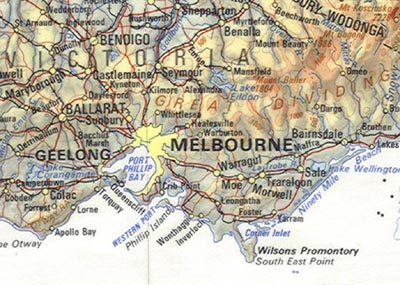
The Great Dividing Range, the major topographic feature of south-eastern Australia, runs essentially north-south, parallel to east coast of Australia, extending in a continuous belt of mountainous terrain from northern Queensland, through New South Wales to Victoria. On reaching the Victorian border, the direction of the Great Dividing Range changes to roughly east-west as it parallels the Victorian south coast, and continues with diminishing height to finish some 100 km to the west of Ballarat. The “Divide” is the dominant topographic feature in the central-west of Victoria, comprising a broad belt of land rising above 500 metres in height, with peaks rising some hundreds of metres more. Many of the historic gold-mining centres occur on, or close to the “Divide”, including Ballarat, Creswick, Daylesford and Kyneton. The area is scenically attractive, not only for the mountainous terrain and associated rivers, but for the extensive areas where native vegetation is preserved or has been replaced by native forests or pine plantations. The “Divide” also has a major impact on rainfall distribution in the region, with heavy falls occurring on the “Divide” and to the south, but creating a partial rain-shadow in the area to the north, near Clunes.
Portion of the 1:5 Million Scale Topographic Map of Australia
Note the positions of the towns of Melbourne, Geelong and Ballarat relative to the roughly east-west trend of the Great Dividing Range. Clunes lies on the northern slopes of the "Divide", about half-way to Maryborough.
(Photograph Hud-vic-001)
Geology
The rocks of the “Divide” consist of ancient sequences of mainly sedimentary rocks, with associated lavas and intrusive igneous rocks. They have been subjected to intense heating and folding, resulting in their deformation, re-crystallisation, and uplift. Granitic rocks occur as intrusions in the folded sedimentary sequences, having been emplaced during this period of mountain building. Quartz veins, some of which contain significant concentrations of gold, also cut across the deformed sedimentary sequences.
The main period of sedimentation, deformation and mountain building occurred in Ordovician or Silurian times, some 400 million years ago. Since then, the mountains have been subjected to glaciation, and fluvial erosion, breaking down the surface rocks and transporting the fragments down-slope, so that now only the roots of the mountain range remain as the “Divide”. Resistant minerals, such as quartz, and inert heavy minerals, such as gold, were preferentially concentrated in the streams and rivers that carried away the detritus from millions of years of erosion, thus forming concentrations of alluvial gold. These rivers generally flowed either north, towards the Murray River, or south, towards the ocean, away from the east-west trending “Divide”.
In late Tertiary times, perhaps a few millions of years ago, the region was subjected to a period of basaltic volcanism. Numerous small volcanoes erupted lava that spilled down the slopes from the eruptive centres. Many of these small volcanoes are known as scoria cones, recognising the cone-like shape of the volcano and the fact that much of the erupted material consisted of scoria-flows or fragments of basalt with numerous sub-spherical holes caused by gas bubbles being “frozen” into the solidifying basaltic magma. Basalt filled the valley floors to depths from a few metres to in excess of 100 metres. In some cases, the flows completely buried alluvial gold deposits, forming deep leads (buried alluvial gold deposits), and diverting the streams to new drainage channels. The basalt was a ready source of stone for construction of fences, houses, public buildings, roads and bridges (the so-called "bluestone"), and the weathering of basalt produced rich soils and a gently undulating land surface for farming regions, such as the Smeaton Plains.
Discovery of Gold
Prior to 1851, pastoralists began to select properties north of the Great Dividing Range. In 1839, Donald Cameron, a Scot, established a homestead in an S-shaped valley carved by a creek through fertile, undulating volcanic plains and named his sheep run “The Clunes” (Gaelic for a pleasant place) after his home in Scotland. There were a number of reports of minor gold discoveries in the district (eg. by William Campbell in 1850, and Dr George Bruhn), however it was not until 7 July, 1851 that James Esmond announced payable gold at Clunes. A small rush followed, but little or no permanent development occurred, as the gold occurred mainly in quartz veins in the basement rock, requiring considerable capital and large cooperative mining activity to recover the gold. Most miners were attracted to easier and richer alluvial gold discoveries at Ballarat, Castlemaine and elsewhere.
Mining the Quartz Reefs
In 1856, the London-based Port Phillip and Colonial Gold Mining Company negotiated an agreement to mine on the privately owned Clunes pre-emptive right, which was part of Cameron’s original pastoral run. The company erected a large stamping battery and pioneered many innovations in company mining. Relatively few companies worked the quartz reefs, although small parties continued to operate, especially under the Cornish “tribute” system, where miners were paid an agreed percentage on the gold won. The system of leasing was disputed by many of the smaller licensed miners, who believed that they were entitled to mine anywhere. These so-called “outsiders” sank shafts outside the lease area and crosscut to the rich quartz veins being mined by the company staff or “insiders”. Numerous disputes occurred between 1857 and 1858, often resulting in fights breaking out both underground and on the surface.
The trend of the reefs was roughly north-south and extended from workings at the South Clunes and Lothair mines, on the southern or town side of Creswicks Creek, to the larger Port Phillip, Yankee, Victoria and Clunes mine sites on the north of Creswicks Creek. The South Clunes and Lothair mines commenced operations in the late 1850s and operated until the 1880s. The Lothair mine was the cause of a near-riot in December 1873, when management attempted to use Chinese labour from Creswick and Ballarat to break a strike. The striking miners, supported by colleagues from other mines and many townsfolk, erected a barricade at the junction of Ballarat and Coghill’s Creek Roads. The coach carrying the Chinese miners was stopped, but a crisis was averted when police advised the managers to turn back. A hotel, subsequently erected at the road junction was named the “Barricade Hotel”
The Port Phillip Mine was classified in 1869 as being the finest mine in the southern hemisphere. The battery consisted of 80 stamps and, during its working life, crushed 1,300,000 tons of quartz yielding nearly 500,000 ounces (over 16,000 kg) of gold worth over 2,000,000 pounds, making it the fourth most productive gold mine in Victoria. Tailing sands were deposited in the creek and subsequently were washed away. The New North Clunes was the richest mine in Clunes, yielding dividends of 750,000 pounds. Total production from the Clunes quartz veins amounted to about 1,250,000 ounces of gold. The vein gold is at least partly found in saddle reefs, as at Bendigo, and the deepest shaft reached 500m.
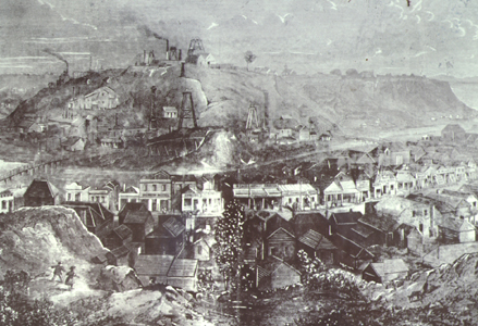
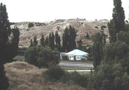
Gold Mine Workings at Clunes
The Port Phillip gold mine in 1869, and a similar view of the old workings that can still be seen today
(Photographs Hud-clu-200 and Hud-clu-201)
The township grew rapidly to become the 5th largest town in Victoria with a population of 30,000 people. The lower end of Fraser Street was the main business area of Clunes from 1857 until the late 1970’s to early 1880’s. The buildings were initially constructed of calico, hessian or canvas, and were progressively replaced by those made from timber and masonry. Fire was a constant threat and caused destruction and rebuilding. In 1872, there were 64 businesses and 12 hotels in lower Fraser Street between Templeton and Camp Streets. Following the closure of the mines in the 1890’s, the centre of the town moved higher up the street, accelerated by closing of insubstantial buildings and losses due to fire.
Magnificent public buildings were erected in the 1970s,during the height of gold mining activity, and have been preserved in excellent condition as a tourist attraction. The Town Hall and Court House was opened in 1873, and is amongst the most significant town halls in Victoria. It is architecturally distinctive and unusual for its combined hall and court facilities. The adjoining Post Office was erected in 1879 and is built on massive foundations, up to 18 feet deep. The large Wesleyan church was erected in two stages in 1863 and 1870 and reflects the strong non-conformist population, boosted by the large number of Cornish miners, that emigrated to Clunes. St Paul's Church of England, with an early timber chapel (1859-60) was relocated from Fraser Street in 1869. A basalt church was constructed in 1870-71 and later extended, reflecting the growing importance of establishment church in the Clunes district.
The gold was worked out by the turn of the century, resulting in many workers moving to other gold fields such as Kalgoorlie.
Deep Leads of the Creswick and Smeaton Districts
The present drainage is roughly parallel to an ancient river system that is now buried beneath younger sedimentary rocks and late Tertiary lava flows. These basaltic lavas flowed down the ancient north-trending valleys, blanketing the river beds to depths up to 100 metres. The lavas covered rich alluvial gold deposits derived from quartz veins within the older Palaeozoic basement rocks. The mining of these “deep leads” was the final and most expensive and difficult phase of the development of the Victorian alluvial gold deposits. It was a stage that required major company investment, expensive exploration based on drilling and underground development, and it exposed miners to great danger through collapse of unstable ground and influx of water.
The Creswick and Smeaton Leads form part of an extensive drainage system that was ranked as “the best gold-producing lead in Victoria”. The Berry-Moolort-Lodden Lead System comprises several major affluents, each with rich near-surface workings in the gullies and tributaries that form their headwaters in the Great Dividing Range. These shallow workings were the focus of early alluvial mining activities, but records of production and details of the mines are poor. The early miners worked small claims of 20 feet square, sometimes amalgamating their claims with other diggers to give economies of scale and efficiency in operation. The workings were shallow, and the main tools were a pick and shovel, gold pan, windlass and bucket. A fee of 3 pounds per month was charged as a licence to dig for gold. It has been estimated that prior to mining the sub-basaltic deep leads, gold worth some 3,500,00 pounds was recovered from the comparatively shallow alluvial gutters surrounding Creswick.
As mining progressed from the pick and shovel operations of individuals and small groups in the near surface workings to the large-scale underground mines operated by companies on the deep leads, the need for expensive plant and equipment also increased. Huge steam engines were required to provide the power for water pumps, compressors, winder engines, and for the puddling and gold concentrating plant, and ample supplies of timber were needed to shore up the underground drives and stopes.
A Mining Disaster
Water was a constant problem for the miners. Rain falling the headwaters of the leads, and that percolating through the sedimentary and basalt cover, quickly saturated the porous gravels and sands of the buried streams and continued to flow down-slope over the eroded surface of reef-rock. Before mining could commence, it was necessary to drain the water using a system of tunnels and pumps. Even with considerable care and experience, deep lead mining remained a dangerous occupation, and water bursts and underground collapses increased the risks to which miners were exposed. In 1877, the downstream continuation of the Australasia lead (near Creswick) being mined from the New Australasia Company’s No. 1 mine was abandoned and allowed to flood. On 12 December 1882, men working in a drive from the New Australasia Company’s No. 2 mine broke into the workings of the No. 1 mine, and water flooded in on thirty-one men who were working in the bottom level. Twenty-seven men were trapped for over two days and, when the rescue party reached them, twenty-two were found to have drowned or been asphyxiated from lack of oxygen. A sum of 25,000 pounds was raised to help the families of the victims, and safety laws were tightened throughout the mining industry.