Settlement of the Geelong District
Port Phillip Bay, Victoria
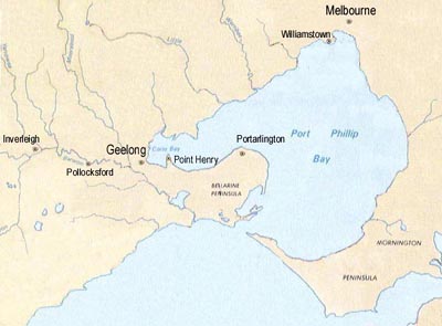
The entrance to Port Phillip Bay from Bass Strait lies between the Mornington Peninsular (east) and the Bellarine Peninsular (west). Melbourne and the port at Williamstown is situated at the northern end of the bay, and Point Henry, Geelong and Corio Bay are at the western end of the bay. The Moorabool and Barwon rivers approach Geelong from the north and west, respectively. The locations of Pollocksford and Inverleigh are also shown. The width of the map is about 120 kilometres.
(Photograph Hud-vic-002); click to enlarge the map; back to return)
Introduction
The following brief summary of the settlement and development of land in the district around Geelong provides an historical background for the area along the Barwon River to the west of Geelong which was to become the future home for James Goddard (arrived in 1847) and Mary Askew (arrived in 1852). The account is focussed on the area near Pollocksford, on the Barwon close to the boundary between the Shire of Murgheboluc and Shire of Gheringhap, and is based on historical information derived from a number of sources For further details of these sources see Credits and Links.
Discovery and Settlement by Europeans
The original occupants of the south-western parts of Victoria were an aboriginal people known as the Wathaurong (Wathawurung). Full-blood members of the tribe died out in the early 1900s, but their descendants are still proud of their ancestry and preserve much of their aboriginal culture.
The Geelong district was sighted by Lieutenant James Grant in December 1800, and in February 1802 a party with Lieutenant John Murray explored Port Phillip Bay including, at its western end, Corio Bay where Geelong now stands. Commander Mathew Flinders made a similar trip in April 1802, anchoring near the sandbar at the entrance to Corio Bay (see Point Henry below) and climbing the You Yang range to the north.
A penal settlement was established by Lieutenant-Governor David Collins on the Mornington Peninsular in October 1803. The settlement, however, was short-lived and was eventually re-located to Hobart. However, prior to its relocation, a Lieutenant Tuckey ventured out from the settlement and was probably the first European to investigate the future townsite of Geelong. In addition, a convict named William Buckley escaped from custody and lived with a local aboriginal tribe for about 32 years (see below).
Opening of the Land by Squatters
For the next twenty years, only whalers, sealers, traders and other seafarers visited the area. In 1824, Hamilton Hume and William Hovell travelled overland to the western shore of the bay on which Geelong is situated. They saw the fine harbour and the excellent condition of the surrounding country and concluded that the site was admirably suited for settlement. The Wathaurong called the bay 'Jillong' and the the land 'Corayo'; somehow, over the years, the names were reversed.
Reports from the Hume and Hovell expedition, and from whalers and itinerant traders, suggested that large tracts of productive land were to be found in the Port Phillip district. In the mid 1830s, there was no formal control of this remote part of the Colony of NSW and a number of individuals and syndicates became active in the region. John Henty and his family and four others moved to the Portland area in 1834 and became Victoria’s first squatters. Squatters were the first Australian pastoralists. They occupied Crown land without official approval or cost, save for a nominal Pastoral Licence fee. The boundary of their “run” or “selection” was marked by “blazing” the trunks of trees around the perimeter. Whilst the system avoided land acquisition and fencing costs, it was necessary to keep the land well stocked, and maintain the sheep flock through the use of shepherds.
In 1835, John Batman inspected the area on behalf of the Port Phillip Association. He was looking for new grazing land as land in Van Diemans Land (Tasmania) was becoming scarce. In the process, he encountered the lost convict Buckley who became an interpreter and guide for the Association. Batman signed the "Geelong Deed" with eight Aboriginal leaders. This “agreement” ceded 500,000 acres of land around Melbourne and 100,000 acres around the future Geelong (including the entire Bellarine Peninsula) to the Association in exchange for a down-payment and a yearly tribute of blankets, knives, tomahawks, mirrors, scissors, clothing and flour. Governor Bourke declared the “agreement” illegal, but nevertheless, from about 1836 onwards, a large number of squatters took up sheep stations in the district.
Founding of Geelong
Governor Bourke visited Geelong in 1837and the town was surveyed. Geelong became the site of only the second police station in the Port Phillip district when Foster Fyans was appointed as police magistrate and protector of Aborigines. In 1838, Geelong was proclaimed a town, and two stores, the Woolpack Inn, and a customs station were opened. The latter is now Victoria's oldest building still standing. Land sales commenced in 1839. The Geelong Advertiser was established as a weekly in 1840, and was the first newspaper outside of Melbourne in the Port Phillip district. It is now the state's oldest morning paper.
By the end of 1841 the population of Geelong was 454, and a post office, two watch-houses and a clerk of works' office had been established. A Presbyterian church was built from 1841-42, with the other denominations following suit in the 1840s. Christ Church (Anglican), located at the corner of McKillop Street and Moorabool Street, remains Victoria's oldest church in continuous use.
By 1848, Geelong's exports exceeded those of Melbourne. This was despite the sandbar at Point Henry, which prevented entry to the inner bay, and despite the absence of local customs facilities, which meant that all ships had to take a detour to Williamstown (near Melbourne). In the 1840s, 90% of local exports consisted of wool, with tallow, live sheep, sheepskins and salted mutton making up most of the balance.
The 1840s and early 1850s saw the creation of Geelong's first industries - flour mills, lime kilns (possibly the first in Victoria), soap works, tanneries and a rope works. After Governor La Trobe married a Swiss wife he encouraged some Swiss to settle in the area in 1842. They established vineyards which produced wines in 1845. The wine industry expanded in the 1850s, particularly with the arrival of some German vignerons, and by 1877 there were over 100 vineyards in the area. International awards were won, but an aphid infestation led to the destruction of all vines in the area in the 1880s.
By 1846 the population had increased to 2065 and, in the late 1840s, Geelong expanded even more rapidly. It was proclaimed a borough in 1849 and Alexander Thomson was elected the first mayor the following year.
Development along the Barwon River
Many of the early squatters, who occupied land in the areas surrounding Melbourne, landed their sheep at what became Williamstown or at Indented Head. However, from 1836, the squatters increasingly moved west, landing their sheep at Point Henry. John Cowie and David Stead, the first to settle, took up land to the northwest in the Moorabool Valley and beyond. Other settlers, including Pollock, went west along the Barwon. By 1836 there were 41,332 sheep in Victoria, by 1838 there were 310,946, and in 1840 there were 782,283.
Squatters heading west from Point Henry had to cross the Barwon and Moorabool Rivers (see map). The Barwon was difficult to cross with livestock, whereas the Moorabool could be crossed at Fyan’s Ford, near the junction of the Moorabool and the Barwon Rivers, which gave access to land along the Barwon River to the west, and at a ford several miles up stream, which provided access to land to the north. Those heading west along the Barwon from Fyan’s Ford, could cross the various creeks on the northern bank of the Barwon, or they could cross the Barwon at Dewing’s or Pollock’s Fords and continue along the southern bank, re-crossing the Barwon at Inverleigh.
Two large companies were able to acquire much of the pastoral land in the vicinity of the Moorabool, Barwon and Leigh Rivers. Members of the now-defunct Port Phillip Association formed the "Derwent Company" and selected in excess of 26,000 acres, stocked initially with 10,000 sheep. Seven Scottish investors formed the "Clyde Company", and in 1838 selected land on the Moorabool River and the Leigh River. Virtually all of the land covered by the present Shire of Bannockburn was now held by the Derwent and Clyde pastoral companies.
The Derwent Company's property Native Hut Creek No. 3, along the Lower Leigh Road (now the Hamilton Highway), was the smallest of the three Native Hut Creek runs at 4000 acres, but it attracted some notable pioneers. Firstly, the Derwent Company in 1838, followed by Edward Willis and Captain Charles Swanston in 1842. Charles Swanston Jnr joined his father’s partner (Edward Willis) on the death of his father in 1850, and they traded as Willis and Swanston. Edward Willis is listed in "The Port Phillip Almanac and Directory 1847" as Willis Edward J.P., merchant: Barwon Terrace, Geelong, and as Willis & Swanston settlers: Pigeon Ponds, Glenelg. Willis Street in Portarlington in the Bellarine district near Geelong is believed to have been named in his honour, as described by W.J. Morrow and the Geelong Historical Society, quoted in http://zades.com.au/bellhs/pastreet.html):
"Willis Street ....no doubt commemorates Edward Willis, who overlanded in 1837 and later entered into partnership with Charles Swanston in the Plenty River area before entering mercantile pursuits in Moorabool Street, South Geelong, at the same time retaining many pastoral interests in the district".
Freehold Land near Pollock’s Ford, Parish of Gheringhap
In 1838, it was decided to subdivide and sell some of the Crown land to the north of the Barwon River, between Fyan’s Ford and Pollock’s Ford in the Parish of Gheringhap. The blocks were roughly one mile square (640 acres), except where they ran down to the irregular northern bank of the river. At the auction on 13 February 1839, Stuart Alexander Davidson bid for, and secured, twelve pieces of land for the original members of John Batman’s Port Phillip Association. These allocations were to Captain Swanston (Sections 3, 4, 5, 6, 10 and 11); Major Mercer (Sections 7, 8, 17, and 18); Thomas Learmouth Snr. (Sections 24 and 25). Subsequently, Captain Montague acquired Sections 3 and 10 and part of Section 5.
Also at the auction, a Geelong agent, Mr. Winter, made a successful bid on behalf of Thomas Brook, an industrialist, of Leytonstone House, York, England. Thomas Brook purchased land known as Sections 1 and 2 of the subdivision, adjoining and to the west of Section 3 and other lots puchased by Captain Charles Swanston (and later owned by Edward Willis and Captain Charles Swanston). These properties extended from north of the Lower Leigh Road to the northern bank of the Barwon River. The road to Pollocks Ford is shown in a map from the 1850s as running south from the Lower Leigh Road along the boundary of Sections 3 and 4 before heading southwest to the ford.
Thomas Brook did not set foot in Australia, but instead sent his seventeen-year-old stepson, James Riley, to inspect the Pollocks Ford property. Young James sailed from Gravesend on the Thames, leaving England via the Isle of Wight in June 1838, and reached Sydney in October 1838. James, who was a remarkably self-possessed young man, first called on the MacArthur’s in Sydney where he was briefed about the Colony and farming. In December 1839, after a trip to inspect his stepfather's property, he wrote a long letter to his mother which commences "I am happy to inform you of my safe arrival home again (Sydney) after an absence of seven months". In that time he and Phillip King travelled by horse through Goulburn and Yass, and crossed the Murrumbidgee River at Gundagai. There he was joined by a Mr Hunter, who accompanied him during the remainder of the trip to Melbourne.
From Melbourne he struck out to the west to inspect the flat, basalt plains to the north of the Barwon River. James Riley was not impressed by the land in Gheringhap, and told his stepfather that it might be alright in time, but that, in his opinion, there were too many stones and rocks.
Early in the following year he set out with young James MacArthur and Count Strezlecki to walk to Melbourne, exploring the flora and fauna. They set out from Goulburn, south of Sydney, on 5 February 1840 and walked and rode down the Murray Valley, up the Snowy Mountains, and climbed the highest peak, which Strezlecki named Mount Kosciusko. They descended and found their way to the top of the Murray Valley, across the High Country and into the coastal plains, which they called Gippsland, in honour of Sir George Gipps, the Governor. Eventually they reached Melbourne and Geelong; an amazing historic journey for one so young!
For several years from about 1840, James Riley developed pastoral interests with others in the Wannan District in western Victoria, which he maintained until 1855. In 1846, he married Harriet Sophie Smith in Sydney, and after reconsidering the benefits of living and raising his family on "Meltham", as the Gheringhap property had been named, moved back and settled there. Following his stepfather's death in September 1850, he learned that Meltham had been bequeathed to his stepfather's bloodline son, Thomas Brook Jr. In July 1859 James Riley had ownership of the property subject to a large mortgage. This and other problems in his pastural interests imposed severe financial difficulties for him, and the property was sold in 1863. A detailed description of the Meltham property has been compiled by Philip L. Brown (see Links and References).
Land Subdivision near Pollocksford on the Barwon River
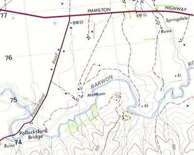
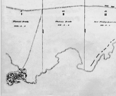
Comparison of a modern topographic map (left) with the land subdivisions sold at auction in 1839 (right). The land bought by Thomas Brook, and later occupied and named "Meltham" by James Riley, is shown as Sections 1 and 2. Land purchased by Captain Charles Swanston, and later owned jointly with Edward Willis, is shown as Section 3.
(Photographs: left God-gee-004; right God-gee-014)
Vineyards Along the Barwon
Swiss and later German settlers contributed much to the establishment of viticulture in Victoria. Wine-making in the Barwon area began to develop when Swiss vignerons at the Neuchatel Canton of Switzerland migrated in the 1840s and 50s. Victorian Governor Charles Joseph La Trobe, superintendent of the Port Phillip District, had spent several years in Neuchatel Canton in Switzerland and this connection led to the emigration of a large number of Swiss families, who followed La Trobe and his Swiss wife, Sophie de Montmolle of Neuchatel, to the Port Phillip District. In the beginning, the Swiss could not own freehold land because they were “aliens”, and so they leased the most suitable land and later owned it in many cases.
The first vines around Geelong were planted in 1842 in the area along the Barwon River near the Barrabool Hills and Pollocks Ford. David Louis Pettavel with Frederick Brequet leased land from James Riley at Meltham and called it Neuchatel. John Belperroud rented land from Edward Willis and Captain Swanston to form Berramongo Vineyard, which had 150,000 vines in it at one time. They were soon followed by eleven settlers from Neuchatel who planted vines around their homes in the Barrabool Hills, to the south of the Barwon River. These vines were used to produce wine that was then sold through the frequently held auctions in the city
In the 1860's, Ebenezer Ward in his book on the Victorian wine industry “Vineyards of Victoria” wrote: "I cannot more appropriately commence the present series of articles upon the vineyards of Victoria than by a description of 'Neuchatel’ (or as it is perhaps better known, 'Pollocks Ford') it being in fact, if not the oldest vineyard in the colony, at all events, the oldest in the Western District. It is situated on the river Barwon about ten miles from Geelong".
The wine industry expanded in the 1850s, particularly with the arrival of some German vignerons. By 1869, there were over 400 hectares planted in the Geelong region making it the largest wine-producing region in the state, and by the 1870s, there were over 100 vineyards in the area, and international awards were being won. In 1875/76, however, there was a severe drought and the Phylloxera wine louse spread throughout the district. In the 1880s, State Government inspectors demanded all vines be destroyed by removal and burning. There has been a modest resurgence of wine production in recent years, with the emphasis on quality rather than quantity wines, and today there remains approximately 300 vine-growing hectares in the Geelong region.